
onX Offroad App
The Ultimate GPS Mapping App for Real Off-Road Adventure
Off-road exploration demands preparation, precision, and the confidence that comes from knowing exactly where you are, even when the trail disappears. The onX Offroad GPS App has become one of the most trusted tools among adventure riders, SxS drivers, overlanders, and snowmobilers, thanks to its powerful mapping features, nationwide trail coverage, and unmatched land-ownership data. Built specifically for those who leave the pavement, onX Offroad transforms any smartphone or vehicle dash into an advanced navigation system built for the backcountry.
Purpose-Built for Off-Roaders
While traditional GPS apps focus on street navigation, onX Offroad is engineered for the demands of dirt. Riders can browse thousands of trails nationwide, each with key details such as difficulty ratings, opening and closing dates, photos, and user-submitted updates. The app goes far beyond trail lines by incorporating over 500,000 recreation points, including campsites, trailheads, water access, and staging areas, priceless data for planning multi-day trips.
Advanced Mapping and 3D Planning
One of onX Offroad’s standout capabilities is its 3D route planning, allowing riders to analyze terrain, elevation profiles, and slope angles with a single click. This makes it far easier to predict technical sections, plan fuel stops, and visualize challenging climbs before loading the bike or riding side by side. Combine that with the app’s intuitive Route Builder, which automatically snaps routes to existing roads and trails, and the planning process becomes fast, accurate, and beginner-friendly.
Offline Maps: Always Know Where You Are
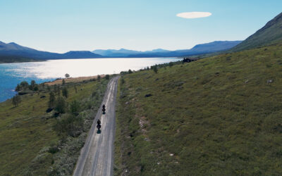
Where the app really earns its place on the home screen is in the backcountry. During our recent ride through the California North Backcountry Discovery Route (BDR), deep in the Sierra Nevada, we tested onX Offroad on three different smartphones: an iPhone 14 Pro, a Samsung S24 Plus, and a Motorola Moto G85 5G. All were mounted to KTMs using SP Connect mounts with anti-vibration modules, powered via USB. Even in rough terrain and constant vibration, all three setups held up beautifully.
Before departure, we pre-downloaded the entire region on each device, a crucial step, since reception dropped out more than once. But onX kept tracking without issue, using the phones’ internal GPS systems. No lag, no hiccups, no sudden “you have no signal” moments. It just worked.
We had spent days planning the route ahead of time using the desktop version of the app. That version is especially good for deep-dive scouting, scanning topography, linking waypoints, and estimating travel times, then syncing everything to each rider’s device. Having every phone on the same track helped us ride as a team without second-guessing the next turn.
And while the ride was mostly smooth, one evening delivered a reminder that the Sierra doesn’t mess around. Racing the fading light, we opted for what looked like a shortcut along a ridge marked “advanced.” It turned out to be an unmaintained route scattered with fallen trees and zero visibility under the canopy. Safe riding quickly became guesswork. In that moment, onX helped us make the smart call: turn back, reroute, and find a maintained road that would get us to pavement and camp without risking a crash in the dark. No drama, no heroic rescues, just a solid, real-time decision backed by a reliable map.
The app’s ability to log our ride, record tracks, and display nearby points of interest, like potential campsites, came in handy more than once. The terrain layer options let us toggle between satellite views, land ownership boundaries, and trail types depending on what kind of info we needed. One feature that did take a bit of time to wrap our heads around was the “My Content” section. It’s powerful, but understanding how routes, tracks, and waypoints are stored took a few taps to figure out. Once we had the logic down, managing our files and switching views became second nature.
We carried a basic backup GPS app as a precaution, just in case a phone failed or we dropped a device mid-ride, but onX was so reliable we never needed it. From forest service roads to loose rock climbs and unexpected weather shifts, the app kept us informed and oriented at every turn.
Real-World Ride: Using onX Offroad in the Sierra Nevada
Here’s what stood out:
- Offline mapping worked flawlessly: no signal, no problem.
- Route recording let us log exactly where we’d ridden, great for reviewing the day or sharing routes later.
- Importing external tracks, like the official BDR route files, was fast and smooth.
- Nearby Points of Interest, like campgrounds or trailheads, helped us make quick decisions on the fly.
- Map layer options gave us detailed views of terrain, property boundaries, and trail types, all in a few taps.
- Integrated weather forecasts meant we didn’t have to switch apps to check for storms coming over the ridge.
We used it every day of the trip, and the more we explored its features, the more we appreciated how well-built the platform is. It’s intuitive, comprehensive, and clearly made by people who actually ride off-road.
Bottom line? onX Offroad made our trip smoother, smarter, and way more enjoyable. Definitely staying on our home screen for the next one.
Land Ownership Data: A Game-Changer for Riders
With the Elite membership, riders gain access to detailed public and private landowners, including boundaries and acreage. This helps avoid trespassing, identify legal access points, and verify trail easements, essential knowledge for navigating areas with unclear signage or mixed land use.
Seamless Integration and Real-Time Tools
The app syncs with CarPlay and Android Auto, bringing maps, trail info, and ownership data directly to the vehicle dashboard. Additional features like weather forecasts, avalanche info in Snow Mode, track recording, collaborative folders, and rider-submitted trail reports make the app a dynamic, evolving tool that improves with every ride.
onX Offroad made our trip smoother, safer, and more enjoyable. It didn’t just show us where to go, it helped us make better decisions when conditions changed. Whether you’re navigating a known BDR or venturing into uncharted singletrack, it’s one of the best tools you can carry in your pocket, or mount on your bars.
Just remember: download your maps before you lose service. And maybe save the gnarly shortcuts for daylight hours.


Photos/Videos: BTA Media – Words: Mike de la Torre
Related Articles

By Two Seconds
A Dakar to Remember – The Benavides Legacy GrowsEvery edition of the Dakar arrives with questions.Who’s in shape? Who’s hiding their hand? Who’s ready to survive the thousand ways this rally can...

The Ride That Didn’t Happen
Some rides never start. Others break apart in silence. This one did both.Egidijus Pudziuvelis had a plan. A light bike, new tires, a desert route open only two months a year. Mauritania was the...
Midnight Sun, Gravel, and Gravity-Fed Fuel
Three friends, three classic Hondas, and a 6,000-mile odyssey to the pinnacle of Europe and back.The Mission Back in August of last year, two friends and I embarked on what would be our most...